Elevation change detection in the Firiza area using GIS techniques
Abstract Category: Science
Course / Degree: Master degree paper
Institution / University: "Babes-Bolyai" University, Geography Faculty (Cluj-Napoca), Romania
Published in: 2010
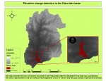
Nowadays, any geographical study has its applicability in G.I.S. Between the large number of applications available in G.I.S. software we can find many that deal with elevation changes. Our study takes advantage of such a tool, “Minus tool”, integrated in the ArcMap 9.3© software, to present the elevation changes that occurred in the Firiza zone (near Baia Mare city/Romania) after the construction of the Stramtori dam. In order to obtain a proper result of the analysis, we used two raster layers (Data Elevation Models), both having the same extent, one representing the area before the dam construction, and the other representing the area after the construction was finished. The result revealed a layer (a map) that returned negative values (“-“representing volume loss) and positive values (“+” representing volume gain). Of course, in this study, the output presented the loss of volume where the Stramtori dam was built, and the other areas were given a value of “0” (zero) or very close to “0”, which means “No Change”. We consider this tool to be very useful in studies that want to examine a change in elevation, like the one presented here.Tags: Dam, Elevation, “Minus” tool, GIS, Baia Mare, Romania.
Dissertation Keywords/Search Tags:
dam,GIS,tool,Romania,change
This Dissertation Abstract may be cited as follows:
Roland-Robert Raiz, „The impact study of the Firiza dam construction over the landscape using GIS techniques”, Cluj-Napoca,2010
| Dissertation Images: | |

|
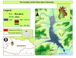
The location on the Firiza lake in Romania (click to enlarge) |

|
Minus tool - elevation changes (click to enlarge) |
Submission Details: Dissertation Abstract submitted by Robert-Roland Raiz from Romania on 17-Jul-2010 13:23.
Abstract has been viewed 3879 times (since 7 Mar 2010).
Robert-Roland Raiz Contact Details: Email: raizrobert@gmail.com
Disclaimer
Great care has been taken to ensure that this information is correct, however ThesisAbstracts.com cannot accept responsibility for the contents of this Dissertation abstract titled "Elevation change detection in the Firiza area using GIS techniques". This abstract has been submitted by Robert-Roland Raiz on 17-Jul-2010 13:23. You may report a problem using the contact form.
© Copyright 2003 - 2026 of ThesisAbstracts.com and respective owners.